|
||||||||||||||||
|
The Cotswold Way National Trail is a scenic, undulating route through quiet Cotswold countryside following the ridge through the Cotswolds Area of Outstanding Natural Beauty (AONB) via the villages of Broadway, Winchcombe, Dursley and Wotton-under-Edge. An attractive and popular trail that offers beautiful rural surroundings with facilities and services always near to hand. The 102 mile route starts at Chipping Campden and ends at Bath.
The Cotswolds Way together with the Cross-Cotswold Pathway and Cotswold Link, forms part of the Cotswold Round, a a 331km/207-mile circuit of the Cotswolds. The Cotswolds Way Trail walk is claimed to be the best marked trail in England. Update. In some locations the Cotswold Way is being diverted from its old route along new and improved paths. Where this occurs, the old path will remain open but will no longer be signed as the Cotswold Way. Cotswolds Public Transport
For accommodation whilst walking the National Trail Walk For detailed map of the Cotswolds National Trail Walk - COTSWOLDS WAY MAP Car Parking for Walkers - Long Stay Chipping Campden Taxis Located at the Town of Chipping Campden We are pleased to offer a new service to walkers in the Cotswold's, secure off-road short or long stay car parking. Especially designed for people walking or touring the Cotswold's and don't need the hassle of car logistics. The service has the added benefit, and security, of electric gates for your peace of mind and convenience. Chipping Campden Taxis (Private Hire) can organise drop-off and pick-up points during the day and deliver you back to your accommodation in the afternoons or evenings. Also, we can organise luggage transfers between your chosen accommodation and remove the stress from the whole process. See more about Secure Car Parking for Walkers |
||||||||||||||||
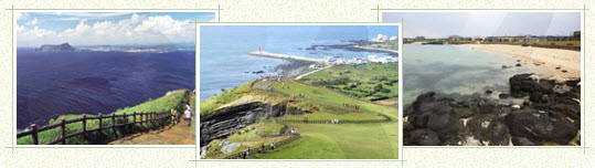
Cotswolds Way National Trail now twinned with Jeju Olle Trail in South KoreaThe Cotswold Way has been twinned with a scenic coastal walk in South Korea, to become one of the world’s first ‘friendship trails’. The initiative will see the 102-mile Cotswold Way Walk twinned to the Jeju Olle Trail, a new and beautiful long distance walking route around the coast of Jeju Island in South Korea.
The link-up is a result of the World Trails conference on the island in 2010, attended by Cotswold Way representatives and hosted by representatives of the Jeju Olle Foundation. The new ‘twinned trails’ will be similar to the twin towns scheme, and it is hoped that the idea will spread across the world, promoting understanding and walking, whilst boosting tourism and local economies. To denote the association, a short circular walk following the Cotswold Way around Stinchcombe Hill near Dursley will be signed with special markers, introducing people to one of the most scenic parts of the Cotswolds Way walk, whilst raising awareness of walking in other countries. A section of Jeju Olle Walk will be marked with the familiar oak sign posts(as seen along the Cotswold Way), inviting visitors to the island to come walking in England. |
||||||||||||||||
| BACK TO TOP | ||||||||||||||||
|
||||||||||||||||
|
||||||||||||||||
| BACK TO TOP | ||||||||||||||||
Cotswolds Way Walk |
||||||||||||||||
| This page last modified Monday, 24-Jul-2023 11:24:31 CEST | ||||||||||||||||
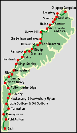 The low limestone hills and agricultural valleys should cause
no problems for anyone who is reasonably fit, but there are a few
steep slopes, rising to the highest point at Cleeve Hill (highest
in the whole of the Cotswolds) near