The Cotswolds Area of Outstanding Natural Beauty (AONB)
Summary
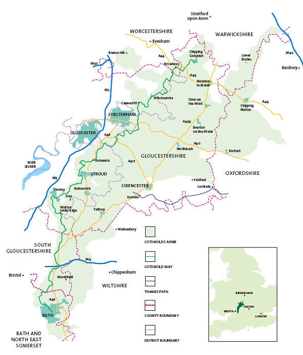
The Cotswolds area of rolling hills and ancient villages and towns where time has stood still for centuries is a protected landscape of national importance. It is managed by the Cotswold Conservation Board and is the largest of the thirty-eight 'Areas of Outstanding Natural Beauty' in England and Wales. A team of over 350 Cotswold Voluntary Wardens, established in 1968, looks after and maintains the region including the dry stone walls and the 3000 miles of public footpath including two national trail walks - The Cotswold Way and a small section of the Thames Path.
The Cotswolds Area of Outstanding Natural Beauty has a population of 139,000 residents and attracts 38 million visitors per year.
There are hundreds of guided walks, riding and cycle trails and events held by such organisations as the National Trust, the Wild Life Trust as well as by Local Authorities.
Over 80% of the landscape is agricultural with principle crops of barley, field beans, oilseed rape and wheat. The rearing of sheep is still an important farming activity and a common sight throughout the Cotswolds.
Geology
The Cotswold Hills forms part of an outcrop of Jurassic rock running from the coast in the English county of Dorset in the south to the coast of the English county of Yorkshire in the north.
The main reason for visiting the Cotswolds is based on the dramtic influence of the oolitic limestone as a prolific building material, used over several centuries for the constuction of ancient market towns and villages which are on every tourists list of 'must sees'. This oolitic limestone on close inspection resembles tiny fish eggs, hence the Greek term oolite or 'egg stone'.
The northern Cotswolds area is particularly famous for its warm honey coloured stone - further south the stone colour is creamier and paler in colour.
Cotswold rivers are classed as salmonid as some contain native brown trout. Cotswold streams provide vital habitats for a wide variety of wildlife including the caddis fly, dipper, white-clawed crafish, water vole and otter.
The Cotswolds is known for its ancient trees and predominantly beech woodlands accounting for some 10% the area.
The Cotswolds contains over 50% of the United Kingdom's total 'Unimproved Jurassic Limestone Grassland' resource which is an important habitat for many rare plants. There are over 300 registered grassland sites totalling 3000 hectares.
Tourism
Tourism is worth £1 billion a year to the Cotswolds economy, with 38 million day visits made in the area per year made and 20,000 jobs depending on it. Tourism is the major source of income and employment in the area.
The residential population within the AONB boundary is circa 160,000 and a further 2 million live on 'the doorstep' within a 20 minute drive.
Cotswolds Tourism is one of the fastest growing sectors in the economy with 10% of the labour force dependent upon it. Tourism is a primary source of employment.
The Cotswolds is one of England's important tourist destinations for those seeking quiet enjoyment for recreation. Increasingly more people, both local and tourists, want to take part in healthy outdoor activities, such as walking, cycling, horse riding and golf.
Special Cotswold Characteristics:-
- Natural Environment - the vast majority of the Cotswolds is unspoilt and offers high-quality experience of nature within varied attractive landscape settings and historic and geological features.
- Ancient Villages and Market Towns - the traditional settlements of the Cotswolds, combined with sympathetic landscape settings, are in themselves the most important attraction of the Cotswolds. Typically nothing has changed in these villages and towns for 300 years with the buildings dating back to 14th,15th & 16th century. One of the most attractive features being the honey-coloured limestone - the beautiful patina gained through the centuries of ageing.
- Visitor Attractions - there is a wide range of visitor and tourist attractions throughout the region including country parks, parks and gardens, historic buildings, archaeological sites and museums and visitor activities.
- Access to the countryside - the Cotswolds is renowned and a well used destination for walking through the open
'Wold' countryside on the 3000 miles of public footpaths. Public rights of way are well maintained and signposted and the area has one of the best kept 'rights of way' networks in the UK. The Cotswolds Area of Outstanding Natural Beauty also contains a number of national and regional walking routes such as 'The Cotswolds Way Trail', 'Macmillan Way', 'Oxfordshire Way' and 'Shakespeare's Way'. Circular routes with self-guided leaflets are also plentiful.
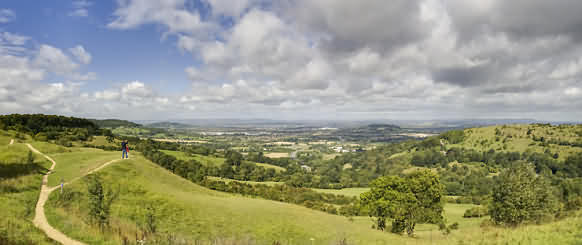
- View Points - particularly from the escarpment looking westwards with extensive views are also established. Examples include - Barrow Wake (near Birdlip) where there are stupendous views over Gloucester to May Hill, with its clump of summit trees and beyond that to the Black Mountains and Brecon Beacons; Broadway Tower from the top of which you can see up to 16 English and Welsh Counties; and Cleeve Hill (the highest point in the Cotswolds at 1083ft above sea level) near Winchcombe.
Painswick Beacon near Painswick also offers superb views towards the Severn Valley.
National Overview
• covers 2,038sq kms (790sq miles).
• was designated in 1966, extended in area in 1990.
• designation purpose is to ensure the conservation.
and enhancement of the natural beauty of the Cotswolds
• is the largest of the 40 AONBs in England and Wales.
• the primary or enabling legislation for the designation of the
area as an AONB was the National Parks and Access to the
Countryside Act 1949.
• The Cotswolds is the second largest protected landscape in England after the Lake District National Park.
|
Local picture
17 local authorities and 297 parish or town councils and parish
meetings have territory in the AONB.
• in June 2000 the Government confirmed that AONBs had
the same landscape quality and status as National Parks.
• IUCN - World Conservation Union recognises the Cotswolds
AONB as a Category V protected landscape, a protected area
managed mainly for landscape protection and recreation.
|
Regional picture
Three Government offices, regional assemblies, regional
development agencies and regional tourist boards have
a territorial stake in the AONB:
• 81% of the AONB lies in the South West (1,651 sq kms).
• 7% in the West Midlands (142 sq kms).
• 12 % in the South East (245 sq kms).
|
|


